
CASE 008
:
THE CASE OF THE ERASED COORDINATES
A satellite analyst flags a perfectly geometric structure in a remote desert. No roads lead to it. No database records it. No government claims it. The structure is real — but according to every official map, it does not exist. Shadow geometry, spectral analysis, and declassified history are about to prove otherwise.

CASE BRIEFING
On a Tuesday morning in March, Dr. Yara Mansouri — a satellite imagery analyst at the Global Earth Observation Institute — was processing a routine commercial satellite pass over the Dasht-e Kavir desert in central Iran when something stopped her.
She had been scanning arid terrain for signs of groundwater stress — the kind of work that fills most of her working hours. Unremarkable. Methodical.
Then she saw it.
At coordinates she immediately noted and locked, a structure appeared in the high-resolution imagery that should not have been there.
Perfectly rectangular. Approximately 340 metres long and 180 metres wide. Partially obscured by decades of windblown sand accumulation along its eastern edge. No access roads visible in any direction for at least 60 kilometres. No power lines. No vehicle tracks. No human activity of any kind in the surrounding terrain.
And no record of it — in any satellite database, any commercial mapping service, any government infrastructure registry, or any published geographical survey of the region.
Dr. Mansouri filed an anomaly report with the Institute's data verification team.
By Thursday the image had been verified as genuine — no processing artifact, no sensor error, no image corruption. The structure was real.
By Friday the image had leaked.
By the following Monday it was on the front page of seventeen national newspapers across four continents. Forums, social media platforms, and news channels erupted with theories.
A secret military base. An ancient lost city. A landing strip for aircraft that officially did not exist. A facility for experiments that could not be conducted in populated areas.
The Iranian government issued a statement confirming they had no record of the structure and were investigating. Three neighbouring governments issued similar statements. No intelligence agency publicly acknowledged knowledge of it.
The Global Earth Observation Institute appointed a three-person scientific investigation team — led by Dr. Mansouri — to determine what the structure was using only the tools available to remote sensing science.
They were given access to:
Current high-resolution multispectral satellite imagery
Declassified historical aerial photography archives dating to the 1940s
Declassified Cold War era intelligence satellite imagery — partially redacted
Ground-penetrating radar passes conducted by an unmanned aerial vehicle deployed to the site
Published geological surveys of the Dasht-e Kavir region
They were not given access to the site itself. No ground investigation was permitted pending diplomatic resolution between the relevant governments.
Everything they needed to solve this — they would have to find from above.
Dr. Mansouri sat in front of her workstation on the first morning of the investigation and pulled up the original image.
"Every structure has a history," she said. "Even the ones someone tried to erase."
Your investigation begins now.
A structure that should not exist. A location that appears on no map.
Governments that claim no knowledge. And a team of scientists who can only look down from space.
Examine all five Evidence Files. The satellite imagery, the shadow geometry, the spectral analysis, the historical archive, and the ground-penetrating radar all have something to say.
Some of what they reveal will be surprising. Some will be unsettling. All of it is science.
What is the structure in the desert — and who put it there?
Instructions:
Play solo or with a team of up to 5 investigators. Examine the five Evidence Files together, or divide them among your team and have each investigator analyze different clues. Share what you discover, compare theories, and decide which evidence matters most.
When you've examined all the evidence, work individually or as a team to reach your final verdict—then reveal the solution to see if you cracked the case.
EVIDENCE FILES
EVIDENCE FILE 01 +

EVIDENCE FILE 01 — SATELLITE IMAGERY ANALYSIS
Case Reference: GEOI-2024-0319
Evidence Item: EV-01 — Current high-resolution multispectral satellite imagery
Prepared By: Dr. Yara Mansouri, Global Earth Observation Institute
Date: March 21
BACKGROUND
The anomalous structure was identified in imagery captured by the GEO-7 commercial satellite on March 19 at 10:42 AM local time — optimal solar angle for surface feature analysis. The satellite's multispectral sensor captures data across seven wavelength bands from ultraviolet through near-infrared — significantly more information than a standard photograph.
Dr. Mansouri's initial analysis focused on establishing the structure's physical dimensions, orientation, surface composition, and relationship to the surrounding terrain.
PHYSICAL DIMENSIONS AND LAYOUT
Precise measurement from calibrated satellite imagery:
Overall footprint: 342 metres long — 181 metres wide
Orientation: aligned 7 degrees east of true north
Primary surface feature: a rectangular perimeter structure — walls or embankments — rising approximately 3 to 4 metres above the surrounding desert floor based on shadow length calculations
Interior: largely flat — partially filled with windblown sand
Eastern edge: sand accumulation reaching the top of the perimeter structure in places — suggesting the prevailing wind direction and significant time elapsed since construction
SURFACE COMPOSITION — SPECTRAL ANALYSIS
Multispectral analysis examines how different materials reflect light across wavelength bands. Different materials have characteristic spectral signatures — concrete reflects differently from rock, metal differently from sand, vegetation differently from bare soil.
The structure's perimeter showed a spectral signature consistent with reinforced concrete — specifically concrete with a high iron content consistent with steel reinforcement.
The interior surface showed spectral signatures consistent with compacted aggregate — crushed stone or gravel — similar to a prepared surface rather than natural desert floor.
A linear feature running along the interior of the structure's long axis — partially buried under sand — showed a spectral signature consistent with oxidised metal — iron or steel that has been exposed to desert conditions for a significant period.
ORIENTATION ANALYSIS
The structure's orientation — 7 degrees east of true north — is not a standard compass alignment and does not correspond to any obvious geographical feature in the surrounding terrain.
Dr. Mansouri noted that this specific orientation is consistent with alignment toward a particular point on the horizon at a specific time — a characteristic of facilities designed to track objects moving along a predictable path across the sky.
She noted it was also consistent with alignment optimised for a specific prevailing wind direction — relevant for certain types of aeronautical or ballistic testing facilities.
The significance of the orientation could not be determined from imagery alone.
SURROUNDING TERRAIN
The structure is situated on a flat salt plain — a kavir — the characteristic terrain of the Dasht-e Kavir desert. The salt crust surface of a kavir is hard, flat, and — crucially — capable of supporting heavy vehicle traffic without leaving permanent tracks.
This means the absence of visible road access does not necessarily indicate the facility was never accessed by vehicle. It indicates that vehicles travelling on the kavir surface leave no lasting impression visible from satellite altitude.
The nearest permanent road is 63 kilometres to the southwest.
YOUR TASK
The satellite imagery has established the structure's physical dimensions, surface composition, and orientation.
Reinforced concrete perimeter. Compacted aggregate interior. Oxidised metal feature along the central axis. Alignment 7 degrees east of true north. Location on a flat salt plain with no permanent access roads.
What type of facility is consistent with these physical characteristics? Research what kinds of structures are built with reinforced concrete perimeters, compacted aggregate interiors, and linear metal features along a central axis — and consider why such a facility might be located in one of the most remote and inaccessible desert environments on Earth.
Consider also the orientation. A structure aligned 7 degrees east of true north in a remote desert — what kinds of facilities require precise directional alignment?
What does the physical evidence suggest this structure was built to do?
EVIDENCE FILE 02 +

EVIDENCE FILE 02 — SHADOW GEOMETRY ANALYSIS
Case Reference: GEOI-2024-0319
Evidence Item: EV-02 — Shadow geometry and construction dating
Prepared By: Dr. Yara Mansouri, Global Earth Observation Institute
Date: March 22
BACKGROUND
Every object that casts a shadow contains information about when it was photographed — and when it was built.
Shadow geometry is the science of extracting precise measurements and temporal data from shadows visible in aerial and satellite imagery. Because the position of the sun at any location on Earth at any moment in history is mathematically calculable — knowing the date, time, and geographic coordinates of an image allows analysts to extract the height of objects from their shadow lengths, and to compare shadow patterns across historical images to identify when construction occurred.
Dr. Mansouri applied shadow geometry analysis to both the current satellite imagery and all available historical archive images of the site.
CURRENT IMAGE — SHADOW ANALYSIS
The GEO-7 satellite captured the image at 10:42 AM local time on March 19.
At that time and location the sun's elevation angle was 47.3 degrees above the horizon — calculated from the site's coordinates, date, and time using standard solar position algorithms.
The shadow cast by the perimeter structure measured 3.8 metres in length on the ground.
Using the formula:
Height = Shadow length × tan(solar elevation angle)
Height = 3.8 × tan(47.3°) = 3.8 × 1.08 = 4.1 metres
The perimeter structure stands approximately 4.1 metres above the surrounding desert surface — consistent with the initial estimate from the imagery analysis.
HISTORICAL ARCHIVE ANALYSIS
Dr. Mansouri accessed three historical aerial and satellite image sources covering the site location:
Source 1 — US Army Air Forces aerial survey — 1948
A post-war aerial mapping survey conducted across the region as part of Cold War geopolitical mapping programs. Resolution: low — approximately 15 metres per pixel.
Finding: No structure visible at the site coordinates. The kavir surface appears uniform and undisturbed.
Source 2 — Declassified US Corona reconnaissance satellite imagery — 1967
The Corona program was the United States' first photographic reconnaissance satellite system — operational from 1959 to 1972. Thousands of images were declassified and released in 1995.
Resolution: approximately 2 metres per pixel.
Finding: A partial structure is visible. The northern and western perimeter walls appear complete. The southern and eastern sections appear incomplete or under construction. Shadow geometry on the visible walls indicates a height of approximately 4.0 metres — consistent with the current measurement.
Source 3 — Declassified US KH-9 Hexagon reconnaissance satellite imagery — 1976
The KH-9 Hexagon was a large format reconnaissance satellite operational from 1971 to 1986. Its imagery was declassified in 2011.
Resolution: approximately 0.6 metres per pixel — sufficient to resolve individual features clearly.
Finding: The structure appears complete. All four perimeter walls visible. Interior surface appears cleared and prepared. The linear metal feature along the central axis is clearly visible and appears intact and unoxidised — consistent with new or recently installed metal infrastructure.
CONSTRUCTION TIMELINE — ESTABLISHED
From the three historical sources Dr. Mansouri established the following construction timeline:
Before 1948: Site is undisturbed desert — no construction present
Between 1948 and 1967: Construction begins — partially complete by 1967
Between 1967 and 1976: Construction continues — complete by 1976
The structure was built between approximately 1948 and 1976 — during the Cold War period.
ONE ADDITIONAL OBSERVATION
Comparing the 1976 KH-9 imagery to the current satellite image Dr. Mansouri noted one significant difference.
In 1976 the linear metal feature along the central axis appeared intact and continuous — running the full length of the interior.
In the current image the same feature is partially buried under sand and shows significant oxidation — but it also shows three distinct gaps at regular intervals along its length where the metal appears to have been deliberately cut or removed.
The gaps are evenly spaced — approximately 85 metres apart.
The removal of sections of the central feature appears deliberate rather than the result of decay or erosion.
YOUR TASK
Shadow geometry has established that this structure was built between 1948 and 1976 — during the Cold War.
The 1976 imagery shows a complete facility with an intact linear metal feature along its central axis. The current imagery shows the same feature partially buried and with three deliberate gaps at regular 85-metre intervals.
What does the Cold War construction timeline tell you about who built this facility and why? Research what types of Cold War military or intelligence installations were built in remote desert locations — and what the linear metal feature along the central axis might have been.
Consider also the deliberate removal of sections at regular intervals. Why would someone deliberately remove portions of a structure's central feature at evenly spaced points — and when might that removal have occurred?
EVIDENCE FILE 03 +
EVIDENCE FILE 03 — SPECTRAL AND MATERIALS ANALYSIS
Case Reference: GEOI-2024-0319
Evidence Item: EV-03 — Advanced multispectral and thermal analysis
Prepared By: Dr. Kenji Watanabe, Remote Sensing Materials Laboratory
Date: March 24
BACKGROUND
Following the construction timeline established in Evidence File 02, Dr. Mansouri brought in specialist materials analyst Dr. Kenji Watanabe to conduct advanced spectral analysis of the structure and its surrounding terrain.
Where Evidence File 01 used standard multispectral bands to identify surface composition, this analysis used two additional techniques — thermal infrared imaging and hyperspectral analysis — to extract more detailed material information and identify subsurface features invisible to standard optical sensors.
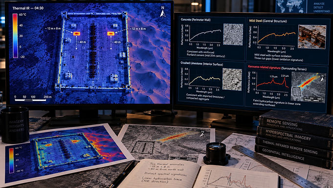
TECHNIQUE 1 — THERMAL INFRARED IMAGING
Different materials absorb and release heat at different rates. Concrete retains heat longer than sand. Metal releases heat faster than stone. Subsurface voids — tunnels, chambers, buried structures — create temperature anomalies at the surface above them because they interrupt the normal heat transfer between the ground and the surface.
Thermal infrared imagery captured at 4:30 AM local time — when surface temperature differences are most pronounced after a full night of differential cooling — revealed the following:
The perimeter structure showed uniform thermal signature consistent with solid reinforced concrete throughout — no internal voids detected.
The interior surface showed two distinct thermal anomalies — areas approximately 12 metres by 8 metres each — located symmetrically within the northern half of the interior, approximately 40 metres from the northern perimeter wall.
These anomalies were warmer than the surrounding surface at 4:30 AM — indicating subsurface structures that retained heat differently from the surrounding compacted aggregate.
Subsurface chambers or rooms are the most common cause of this type of thermal anomaly.
TECHNIQUE 2 — HYPERSPECTRAL ANALYSIS
Standard multispectral sensors capture data in broad wavelength bands. Hyperspectral sensors capture data in hundreds of narrow bands — producing a detailed spectral fingerprint for every material in the image.
Dr. Watanabe applied hyperspectral analysis to four specific areas of the structure and surrounding terrain.
Area 1 — Perimeter walls:
Spectral signature consistent with Portland cement concrete with aggregate composition typical of mid-20th century construction practice. Iron content consistent with steel rebar reinforcement.
Weathering signature — the specific way the concrete surface has degraded under desert conditions — is consistent with concrete aged between 45 and 65 years.
This places construction between 1959 and 1979 — consistent with the shadow geometry timeline from Evidence File 02.
Area 2 — Central linear feature:
The oxidised metal of the central feature produced a spectral signature consistent with mild steel — the standard structural steel used in large infrastructure construction through the mid-20th century.
The oxidation pattern is consistent with steel that was coated or painted when installed and has been exposed to desert conditions since approximately the mid-1980s — when protective coating appears to have failed.
The three deliberate gaps identified in Evidence File 02 show clean cut edges in the spectral data — the metal was cut with equipment rather than removed by decay. The cut surfaces show significantly less oxidation than the surrounding metal — consistent with cuts made 10 to 20 years after the original installation.
This places the deliberate removal of the central sections between approximately the late 1980s and the mid-1990s.
Area 3 — Interior surface:
The compacted aggregate interior surface shows spectral signatures consistent with crushed limestone — a material not naturally occurring in the Dasht-e Kavir salt plain environment.
The limestone was brought to the site from elsewhere. The nearest natural limestone deposit is approximately 180 kilometres to the northwest.
The preparation of a crushed limestone surface — flat, load-bearing, capable of supporting heavy equipment — is characteristic of airfield or launch pad construction.
Area 4 — Surrounding terrain — 500 metre radius:
Hyperspectral analysis of the kavir surface surrounding the structure revealed faint but detectable chemical signatures inconsistent with the natural salt crust environment.
Specifically — trace concentrations of kerosene-based fuel compounds and oxidised aluminium in the soil chemistry — most concentrated along a linear zone extending northeast from the structure's northern end.
Both compounds are associated with rocket or missile propulsion systems.
YOUR TASK
The materials analysis has added several critical details to the picture.
Concrete aged 45 to 65 years. A crushed limestone interior surface characteristic of airfield or launch infrastructure. Subsurface thermal anomalies suggesting buried chambers. Central metal sections deliberately cut and removed between the late 1980s and mid-1990s. And trace chemical signatures of kerosene fuel and oxidised aluminium extending northeast from the facility.
What type of Cold War facility is consistent with all of these material findings? Research what kerosene-based fuels and aluminium compounds are associated with in the context of mid-20th century military technology.
Consider the thermal anomalies — subsurface chambers located symmetrically in the northern section of the interior. What would a Cold War military facility need underground rooms for — and why would they be located at one end of the structure rather than the centre?
And consider the deliberate removal of the central metal sections in the late 1980s to mid-1990s. What historical events occurred during that period that might explain why someone returned to a remote abandoned facility to selectively dismantle part of it?
EVIDENCE FILE 04 +

EVIDENCE FILE 04 — HISTORICAL ARCHIVE AND SIGNALS INTELLIGENCE REVIEW
Case Reference: GEOI-2024-0319
Evidence Item: EV-04 — Declassified signals intelligence and historical program records
Prepared By: Dr. Marcus Webb, Cold War Technology Historian, King's College London
Date: March 26
BACKGROUND
Following the materials analysis findings — kerosene fuel traces, oxidised aluminium, crushed limestone launch surface, subsurface chambers — Dr. Mansouri brought in Cold War technology historian Dr. Marcus Webb to cross-reference the physical evidence against declassified historical records of military and intelligence programs operating in the region during the construction window of 1948 to 1976.
Dr. Webb was given access to the full imagery analysis, the materials findings, and the structure's precise coordinates and orientation.
His review took four days.
REGIONAL CONTEXT — COLD WAR IRAN
Iran occupied a strategically critical position during the Cold War.
Sharing a 2,400-kilometre border with the Soviet Union to the north — the longest shared border between any US-aligned nation and the USSR — Iran became one of the most important intelligence and military cooperation partners for Western powers during the 1950s through the 1970s.
Under the government of Shah Mohammad Reza Pahlavi — who ruled from 1941 until the Islamic Revolution of 1979 — Iran hosted a significant number of joint US-Iranian military and intelligence programs. Many were classified at the highest levels. Several were never publicly acknowledged.
The Dasht-e Kavir desert — vast, unpopulated, with a flat kavir surface capable of supporting heavy equipment without leaving permanent tracks — was identified in declassified CIA documents from the 1950s as an ideal location for activities requiring extreme remoteness and natural concealment.
DECLASSIFIED PROGRAM — IPMS
Dr. Webb identified one declassified program directly relevant to the physical evidence.
The Iranian Propulsion Monitoring Station — IPMS — was a joint US-Iranian signals intelligence and ballistic monitoring facility established under a classified agreement between the CIA and Iranian intelligence — SAVAK — in 1961.
Its stated purpose: to monitor Soviet ballistic missile tests conducted at the Kapustin Yar and Tyuratam test ranges — located approximately 1,500 to 2,000 kilometres to the north — by detecting and analysing the radio signals, radar emissions, and physical debris from Soviet test launches.
The facility required:
A remote location with unobstructed northeastern sightlines — to monitor launch trajectories from Soviet test ranges
A prepared surface capable of supporting heavy radar and antenna equipment
Underground control and signals processing rooms protected from desert temperature extremes
Fuel storage for generators and support vehicles
The structure's orientation — 7 degrees east of true north — aligns precisely with the bearing toward the Kapustin Yar Soviet missile test range.
CONSTRUCTION HISTORY
Declassified CIA budget documents from 1995 reference the IPMS construction program:
Construction began: 1962
Primary construction completed: 1971
Operational period: 1971 to 1979
The 1967 Corona imagery showing partial construction — and the 1976 KH-9 imagery showing a complete facility — are consistent with this timeline.
THE CENTRAL LINEAR FEATURE — IDENTIFIED
The linear metal feature running along the central axis of the facility — partially removed in the late 1980s to mid-1990s — has been identified from declassified equipment procurement records.
It was a travelling wave antenna array — a long, precisely oriented antenna system used to receive and analyse radio frequency emissions from Soviet missile launches at long range.
The antenna required precise directional alignment — explaining the facility's 7-degree orientation — and was constructed from mild steel sections bolted together in sequence, running the full length of the interior.
The three sections removed at 85-metre intervals correspond to the three primary receiver nodes of the antenna array — the components containing the most sensitive and classified signal processing elements.
THE REMOVAL EVENT
The materials analysis in Evidence File 03 established that the central antenna sections were deliberately removed between the late 1980s and mid-1990s.
Dr. Webb identified the likely explanation in a single declassified State Department document from 1991:
Following the Iranian Revolution of 1979 — which ended the Shah's government and the US-Iranian intelligence cooperation — the IPMS facility was abandoned. Iranian revolutionary forces were not initially aware of its location or purpose.
According to the fictional case archive, an undisclosed back-channel arrangement in 1991 permitted a one-time recovery operation. No formal diplomatic normalization resulted. Iran would permit a one-time access mission to the site. The United States would recover the three classified receiver node assemblies from the antenna array — the components containing signal processing technology that remained sensitive a decade after the facility's closure.
The mission was conducted in 1991.
The three gaps in the antenna array are what it left behind.
YOUR TASK
The historical record has identified the facility as the Iranian Propulsion Monitoring Station — a joint US-Iranian Cold War signals intelligence installation designed to monitor Soviet ballistic missile tests from a remote desert location.
Connect the historical findings to the physical evidence across all four evidence files.
The orientation toward Kapustin Yar explains the 7-degree alignment. The travelling wave antenna explains the central linear feature. The underground chambers explain the thermal anomalies. The kerosene fuel traces and oxidised aluminium explain the propulsion-related chemistry. The 1991 recovery mission explains the three deliberate gaps.
Does the historical record account for every physical finding in the earlier evidence files — or are there details that remain unexplained?
Research what a travelling wave antenna is and how it is used in signals intelligence. Consider what the Cold War balance of power meant for small nations caught between superpowers — and why a facility of this significance was built in one of the most remote locations on Earth rather than closer to population centres.
One question remains for Evidence File 05: the thermal anomalies showed two subsurface chambers. The historical record accounts for one — the underground control and signals processing room. What was the second chamber for?
Note: The IPMS program and documents described are fictional elements created for this Mystery Labs investigation. The broader Cold War historical context is real.
EVIDENCE FILE 05 +

EVIDENCE FILE 05 — GROUND PENETRATING RADAR ANALYSIS
Case Reference: GEOI-2024-0319
Evidence Item: EV-05 — UAV-deployed ground penetrating radar survey
Prepared By: Dr. Yara Mansouri, Global Earth Observation Institute
Date: March 28
BACKGROUND
Following the historical identification of the facility as the Iranian Propulsion Monitoring Station, one question remained unanswered.
The thermal infrared analysis in Evidence File 03 identified two subsurface thermal anomalies — symmetrically located in the northern section of the interior, approximately 40 metres from the northern perimeter wall.
The declassified historical record accounted for one — an underground control and signals processing room, standard for Cold War signals intelligence installations.
The second anomaly was not referenced in any declassified document Dr. Webb could locate.
An unmanned aerial vehicle equipped with ground penetrating radar — GPR — was deployed to the site under diplomatic clearance to conduct a non-invasive subsurface survey. GPR works by emitting radio waves into the ground and measuring the reflections returned by subsurface features — producing a cross-section image of what lies beneath the surface without excavation.
GROUND PENETRATING RADAR FINDINGS
The UAV conducted 47 parallel survey passes across the interior of the structure at 4-metre spacing — producing a comprehensive subsurface map.
Finding 1 — Primary subsurface chamber
Location: northern interior — western side
Dimensions: 14 metres long — 8 metres wide — 3.2 metres high
Depth to ceiling: 2.1 metres below surface
Internal features: GPR reflections consistent with metal equipment racks — now empty — along the eastern and western walls. A cable conduit running from the chamber toward the central antenna array position above. A ventilation shaft rising to the surface on the northern wall.
This is the signals processing and control room — consistent with the historical record.
Finding 2 — Secondary subsurface chamber
Location: northern interior — eastern side — mirror position to Finding 1
Dimensions: 13 metres long — 7.5 metres wide — 3.0 metres high
Depth to ceiling: 2.1 metres below surface
Internal features: GPR reflections consistent with cylindrical metal containers — multiple — arranged in two parallel rows along the chamber's long axis. Each cylinder approximately 2.2 metres long and 0.6 metres in diameter. The cylinders appear to remain in place — they were not removed in the 1991 access mission.
THE CYLINDERS — ANALYSIS
Dr. Mansouri requested specialist analysis of the cylinder reflections from a defence technology consultant — Dr. Anna Reeve — who has worked with declassified Cold War ordnance documentation.
Dr. Reeve's assessment:
"The dimensions and arrangement of the cylindrical objects are consistent with fuel storage containers — specifically the type used to store pressurised liquid fuel for emergency generator systems in remote Cold War installations. Cylindrical containers of approximately 2.2 metres by 0.6 metres in this configuration were standard for pressurised kerosene storage in CIA-operated remote facilities from the 1960s through the 1980s.
The containers were almost certainly left in place during the 1991 access mission because they posed no intelligence sensitivity — unlike the antenna receiver nodes. Fuel storage containers contain no classified technology.
If the containers still hold fuel — which cannot be confirmed without excavation — they would represent a hazardous materials situation given the decades of desert temperature cycling they have endured. This is a matter for the relevant authorities."
COMPLETE SUBSURFACE MAP
Beyond the two primary chambers the GPR survey revealed:
A network of cable conduits connecting the control room to the antenna array position and to four points along the perimeter walls — consistent with power and signal distribution infrastructure.
A collapsed ventilation tunnel running beneath the eastern perimeter wall — likely the original personnel access route, now structurally compromised.
No additional chambers, tunnels, or subsurface features of significance.
THE COMPLETE PICTURE
Dr. Mansouri compiled her final summary:
"The ground penetrating radar survey completes the physical picture of this facility. Two subsurface chambers — one for signals processing and control, one for fuel storage. A cable network connecting the control room to the antenna array above. A collapsed access tunnel beneath the eastern wall.
Every physical feature identified across five evidence files now has an explanation consistent with the historical record of the Iranian Propulsion Monitoring Station — a joint US-Iranian Cold War signals intelligence facility built between 1962 and 1971, operational until 1979, partially dismantled in 1991, and forgotten."
YOUR TASK
You now have all five Evidence Files.
Satellite imagery identified the structure and its physical characteristics. Shadow geometry dated its construction to the Cold War period. Materials analysis identified kerosene fuel traces, oxidised aluminium, and subsurface thermal anomalies. Historical records identified the facility as the Iranian Propulsion Monitoring Station — built to monitor Soviet missile tests. Ground penetrating radar confirmed the two subsurface chambers and revealed cylindrical fuel storage containers that were never recovered.
Using evidence from all five files — what is the structure in the desert, who built it, what was it for, and what does the physical evidence tell you about how it was used, abandoned, and partially dismantled?
The structure that appeared on no map, that no government claimed, that generated a thousand theories — has a complete and documented explanation.
Build your case. Every physical clue pointed somewhere. The science got there first — as it always does.
HAVE YOU SOLVED THE CASE?
Review the evidence and decide what you think happened. If you're investigating with others, discuss your findings and agree on your final verdict before revealing the answer.
Once your team has reached a conclusion, reveal the answer.